Carmera, the mapping startup for autonomous vehicles, raises $20 million
Autonomous vehicles need more than a brain to operate safely in a world filled with obstacles. They need maps. Or more specifically, self-driving vehicles need maps that constantly refresh and can deliver important information — like that sudden lane closure due to construction or a double-parked vehicle — so they can take the safest and most efficient route possible.
This specific need has provided an opening for startups in what once looked like a locked-up mapping market dominated by a few giants.
Carmera, a New York-based mapping and data analytics startup, is one of them. The company, which came out of stealth two years ago, has now raised $20 million in a Series B funding round led by GV, formerly known as Google Ventures. Carmera previously raised $6.5 million.
The company announced the funding raise Thursday along with a few other updates, including a new feature on its autonomous mapping product and a partnership with New York City. The capital will be used to hire more talent and expand.
“We’ll be doing the most aggressive hiring we’ve ever done this next year,” Carmera co-founder and CEO Ro Gupta told TechCrunch, adding that the company will mostly focus on building out its New York and Seattle offices. Carmera, which has about 25 employees, plans to have more than 50 by the end of next year.
“The money also allows us to be more prospective than simply reacting to customer needs,” Gupta added.
In other words, Carmera can move into new markets where it suspects there will be a need in the future, not just wait for a call from their customers. One of those customers is Voyage, the autonomous driving startup that currently operates self-driving cars in retirement communities.
Carmera has an interesting business model, and one that’s likely attractive to investors looking for startups with a present-day revenue stream. The company describes itself as a street intelligence platform for autonomy. Its main product is the Carmera autonomous map, a high-definition map for autonomous vehicle customers like automakers, suppliers and robotaxis.
The twist here is that the company uses data gleaned from its other product — a fleet-monitoring service used by commercial customers with vehicles driven by humans — to keep those AV maps fresh. The fleet product is a telematics and video monitoring service used by professional fleets that want to manage risk with their vehicles and drivers.
These fleets of camera-equipped human-driven vehicles deliver new information to the autonomous map as they go about their daily business in cities. Carmera calls this a “pro-sourcing” swarm.
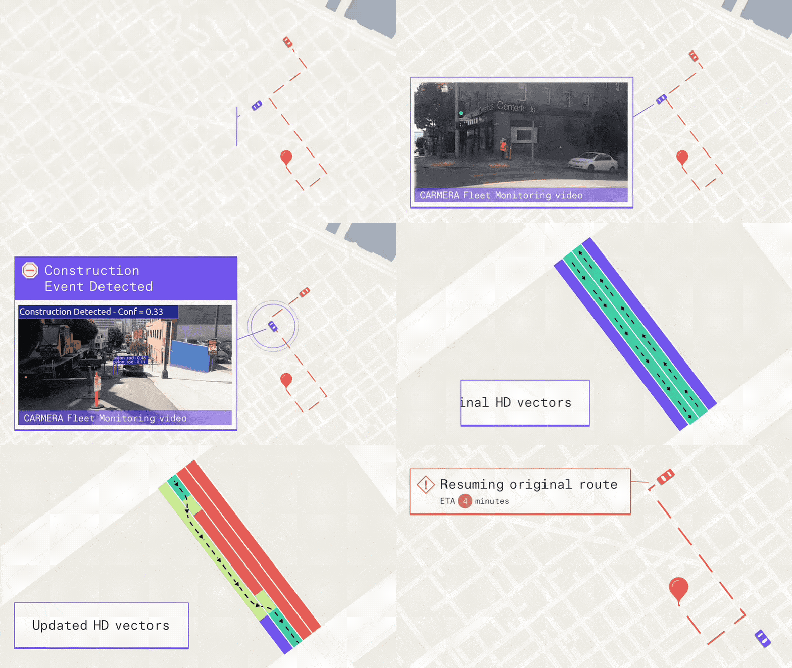
The startup has now added a real-time events and change-management engine to its autonomous map that Gupta contends is a major leap forward because it not only provides more detailed information to self-driving vehicles, it gives these driverless vehicles a suggested path.
In some mapping products, there’s generally a base map and then a dynamic overlay. The problem, Gupta explains, is that when things change, like a lane closure, the dynamic map only flags it, leaving it up to the vehicle to figure out what to do next.
“That works fine when humans are driving, it just doesn’t go far enough for AVs,” Gupta said. “What they need to know is how do I path plan around it?”

Carmera’s real-time events and change-management feature
The map will detect a change in milliseconds, classify it within seconds and then validate and redraw the base map within minutes, according to Carmera. The company is giving companies deploying autonomous vehicles API access to this data at every stage.
Carmera also has a “site intelligence product,” a jargon term that means the company provides spatial data and street analytics (like how pedestrians move within a particular intersection) to urban planners.
Carmera announced Thursday it will begin sharing data such as historical pedestrian analytics and real-time construction detection with New York City’s Department of Transportation. Carmera will get access to key city data sets in return. The partnership with NYC DOT follows an earlier-data sharing initiative with the Downtown Brooklyn Partnership.
Powered by WPeMatico